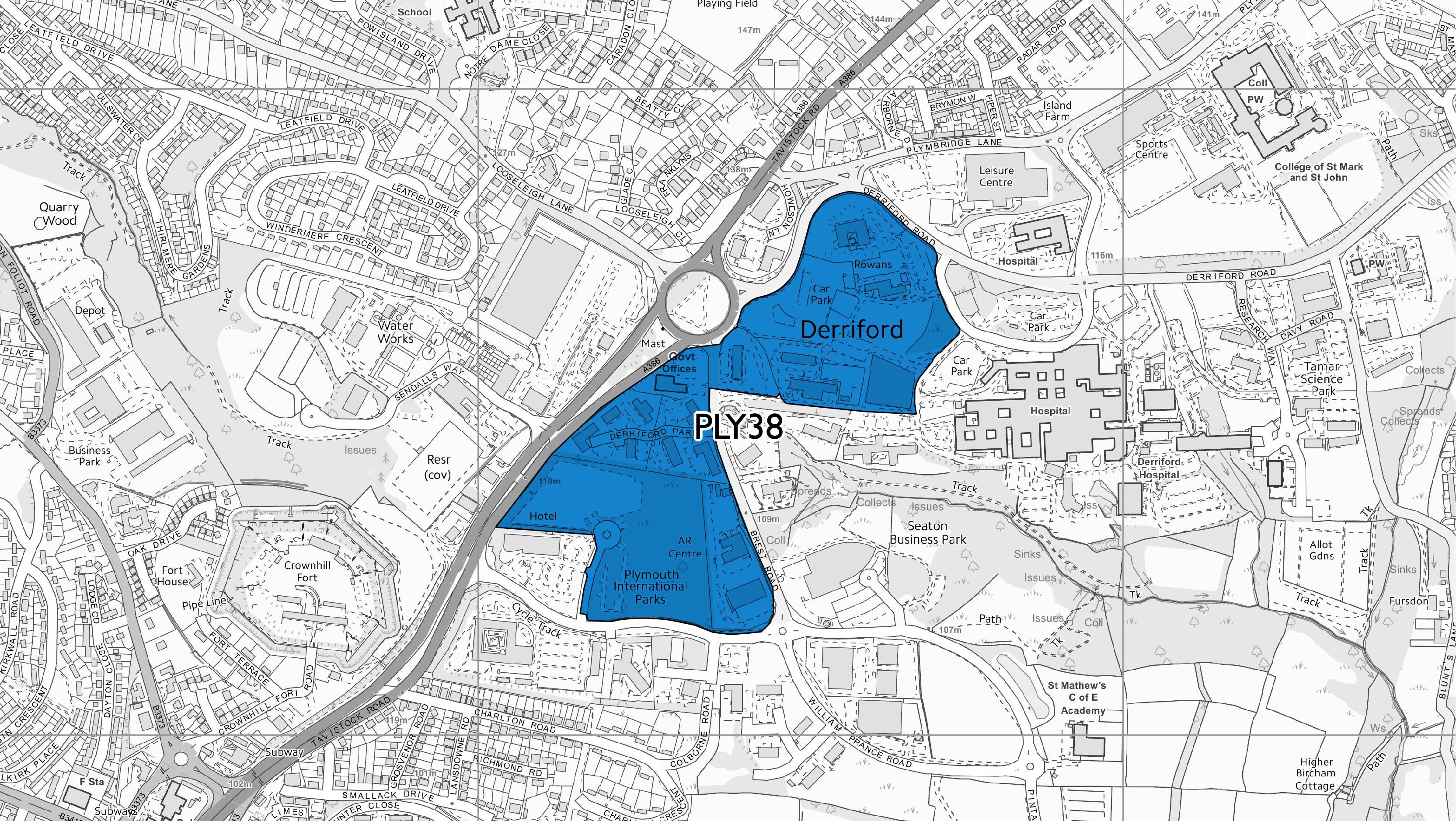
PLY38 - Derriford commercial centre
The Plymouth and South West Devon Joint Local Plan has now been adopted! To find out more please visit the Plymouth and South West Devon Joint Local Plan: Adoption page.
Visit the interactive Plymouth Plan to see other policies that affect decision making across Plymouth City including the Council and its partners.
Land situated between Derriford hospital and William Prance Road, and incorporating the North West Quadrant site, Derriford Business Park and the former Seaton Barracks Parade Ground is allocated for a mix of uses comprising new commercial floorspace in the form of retail, medical / health related uses, B1 offices and workshops, leisure and community uses, education, and residential. The overall balance of uses will be influenced over time by market conditions. However, the site should deliver a genuinely mixed use development of urban scale and intensity. The site comprises land in different ownerships and will be developed over time in accordance with a strategic masterplan that sets out an overall framework for delivery and identifies key infrastructure fixes. Specific provisions are as follows:
- The commercial centre will have the status of a district centre in Plymouth's retail hierarchy. The role of the centre’s retailing function is to fill a gap in main food shopping provision in the north of Plymouth and to provide retail facilities to serve those who work, study and visit the area's facilities and services. It will also provide a catalyst for the wider regeneration and development of the Derriford area, helping to create a new heart for the north of Plymouth. Food retailing shall be provided at a level which anchors other retail facilities in the centre and meets the need for main food and convenience shopping facilities for local communities. Non-food shopping and leisure floorspace should be limited to a scale and type which will not result in the centre having a significant adverse impact (including when assessed cumulatively) on the vitality and viability of, and investment in, the City Centre, nor on the ability of other centres in the retail hierarchy to perform effectively their primary role for their local communities. All proposals which form part of the development of the commercial centre or future changes to it which include retail floorspace will be determined and controlled in accordance with the application of the sequential and impact tests as provided for in Policy DEV16.
- A mix of residential development should be provided throughout the scheme. The site is considered suitable for higher density forms of home, homes above commercial units, homes for the elderly (including extra care), student housing and homes for staff at the hospital. Provision is made for in the order of 664 homes.
- Office accommodation should be provided throughout the scheme, representing Derriford's role as the secondary location for office development in the city. Provision is made for in the order of 34,000 sq.m. (net).
- The northern part of the site, focused around the North West Quadrant site, will be most intensively developed, including:
- New health care and community facilities, offices, and multi-storey car parking in the areas closest to the hospital to support its operation by enabling non-acute and wider ‘wellbeing’ care to be separated from the acute care provided in the main hospital buildings.
- Smaller retail and food and drink uses designed to support the visiting and working communities of the immediate surroundings as well as a significant new residential population to the north of the site.
- Small to medium sized retail units suitable for food retailing in the highly prominent parts of the North West Quadrant site closer to the Derriford roundabout, along with the Derriford Gate office site, with separate access.
- The southern part of the site focused around the former Seaton Barracks parade ground will be developed to include:
- Office and business park development.
- Potential for larger format retail for which there is insufficient space in the northern part of the site.
- Other uses that specifically support the business park and support place-making objectives for the centre, including limited scale food and drink and leisure uses.
- Residential uses, where these can be successfully mixed with commercial uses by for example, being located above commercial uses, wrapping buildings to animate otherwise dead frontages, or by being located discretely in a manner that creates an attractive residential environment.
- Further residential development in the eastern area where there are excellent east-facing views, including on parts of the Territorial Army site (should these become available) where east-west links across the site to the Derriford Community Park can be created.
- The Derriford Business Park provides a longer term opportunity for connecting the northern and southern areas with a range of town centre type uses mixed with residential.
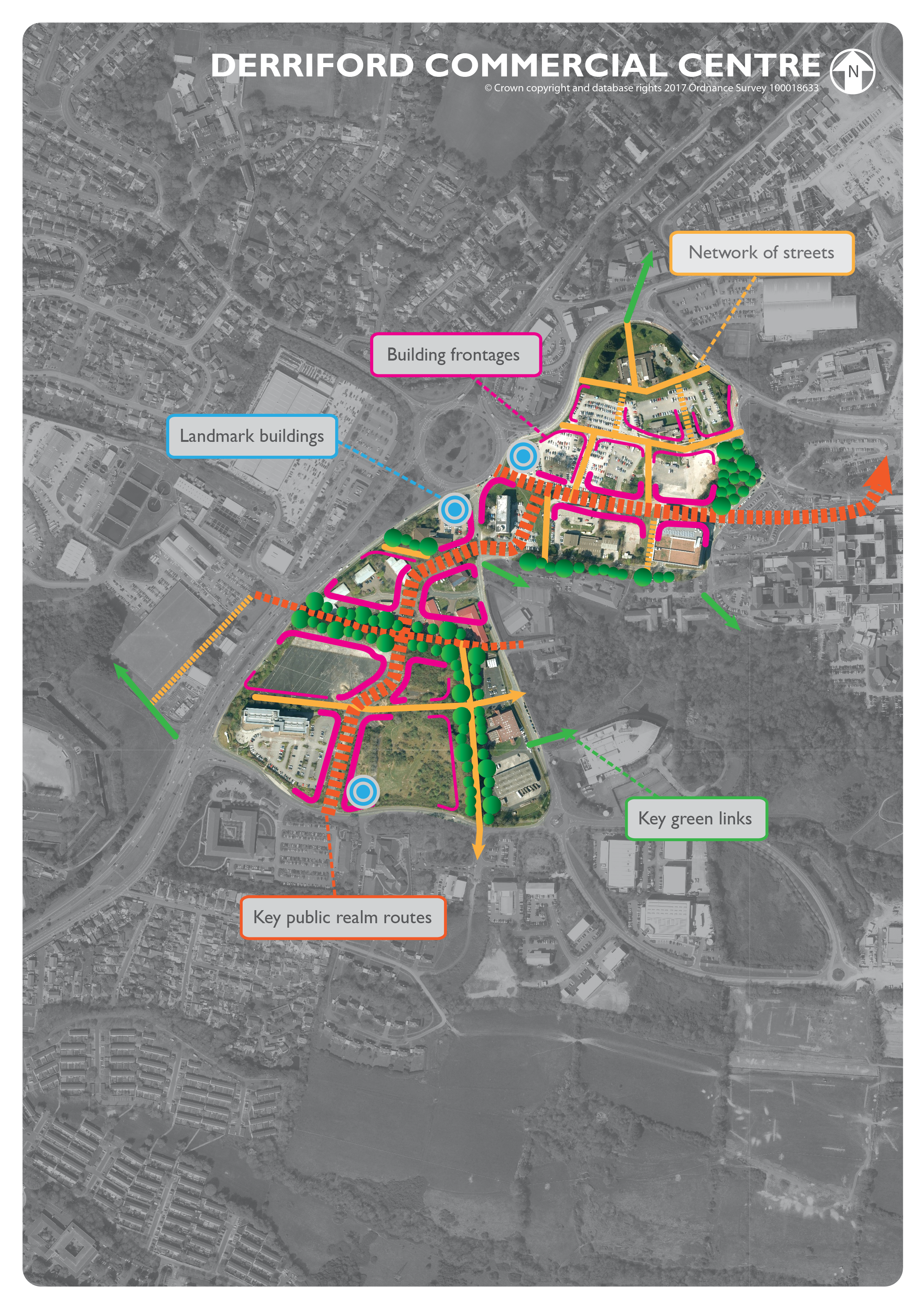
- Applications for development within the site will be expected to accord with the strategic masterplan, and to contribute towards the delivery of the network of on-site streets and other infrastructure essential to deliver the centre. Essential infrastructure includes:
- The creation of a strong, legible pedestrian and cycling route from the hospital entrance and public transport interchange to the junction of Morlaix Drive with Brest Road (‘The Seaton Arc’).
- Improved bus and staff car parking access for the hospital site via Morlaix Drive.
- An extension of the Future Inn access road through to Brest Road, to provide the opportunity for buses to travel northbound through the site.
- A new/improved junction linking the access road to Brest Road and Morlaix Drive junction.
- A new junction with William Prance Road and vehicle access route along the eastern boundary of the former Seaton Barracks Parade Ground site.
- The inclusion of green links throughout the area including, a new east-west linear park along the existing tree line providing street access to new development as well as a footpath and cycling route linking the Sendall’s Way crossing of the A386 directly to Brest Road and good connection to Derriford Community Park.
- Space should be provided to create a high quality pedestrian and cycling bridge link across the A386 in the future, depending on the future development of the Glacis park site on the west side of the road.
- A communal surface water sustainable urban drainage scheme that is designed to deliver landscape, biodiversity and amenity benefits.
- Providing for future connection to district heating networks.
- Development should provide proportionate contributions to strategic transport improvements and programmes.